Wind | Services
Meteorological Tower Construction / Wind Resource Assessment
It takes more than an occasional breeze to justify a wind turbine. To determine if a site is a good candidate for wind energy development, specific wind characteristics must be measured at multiple heights; data logged, maintained, qualified and certified. Then the findings are interpreted. Wind resource modeling across landscapes can then unlock the cumulative power generation potential for any given site.
Wind Resource Assessment

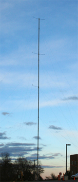
A typical Meteorological
Tower Installation
To be truly useful, wind data accounts for two major factors:
1. Long-term weather patterns – The amount of wind varies significantly on a month-to-month basis. An average wind speed near 6 meters/second (approximately 15 miles/hour) is considered a minimum for most commercially-viable developments.
2. Hub height of potential turbines - Utility scale turbine towers have heights of up to 100 meters and sometimes beyond. A meteorological tower is often the primary resource for estimating long-term wind resources and wind shear (e.g. how wind varies with elevation). After collecting a minimum of three months of data, a wind resource profile is created. Boreal then correlates this data between the tower's anemometers and another weather station, usually at the nearest airport to develop long term averages. A meteorological tower is the primary method for estimating long-term wind resources at the future wind turbine height.
Installation and Measurement
Boreal’s field crew has years of experience installing meteorological towers in some of the most remote and challenging sites – from seashore to mountain tops. We have identified successful wind sites and provided justification for installing wind turbines based on wind resource assessment and modeling.
Based on the data gathered by our anemometry, Boreal performs sophisticated wind resource modeling to aid in the design and optimization of wind farm development at various sites in New England and beyond.
No site, no matter how urban or remote, is too difficult for installation of measurement equipment. The Boston Museum of Science WindLab is studying wind patterns and energy production potential as a resource for its visitors.
 Wind power
 Solar power
 Consulting
 Selected clients
 Boreal news